Lyn Wilkerson: 37 books

by Lyn Wilkerson
Language: English
Release Date: April 25, 2010
Language: English
Release Date: April 25, 2010
This edition in the Historical Cities series explores the French Quarter and surrounding area of New Orleans. Simple to use maps provide make a walking tour of the city's historic sites entertaining and educational. GPS coordinates are provided for the more tech savvy user. More than 50 sites are identified, with text backgrounds based on the 1930's and 40's American Guide Series.
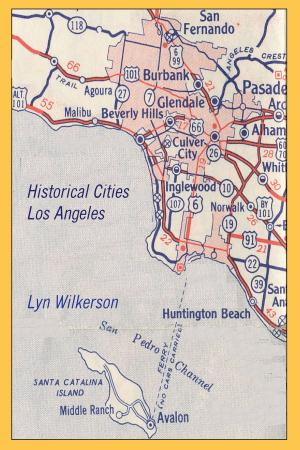
by Lyn Wilkerson
Language: English
Release Date: December 13, 2010
Language: English
Release Date: December 13, 2010
This edition of our Historical Cities series explores the city and county of Los Angeles, including the surrounding environs of Beverly Hills, Hollywood, Santa Monica, Long Beach, San Pedro, and Pasadena. Over 230 historical sites and landmarks are provided with historical background and GPS coordinates. Reference maps provide simple navigation aids.

by Lyn Wilkerson
Language: English
Release Date: March 6, 2011
Language: English
Release Date: March 6, 2011
This edition in the Historical Cities series explores the history and historic places of Kansas City, Kansas and Kansas City, Missouri. Over 80 points of interest are presented, with reference maps to assist navigation and GPS coordinates for all listed sites. Also included are sites in Independence, Missouri and Shawnee, Kansas.

by Lyn Wilkerson
Language: English
Release Date: January 12, 2011
Language: English
Release Date: January 12, 2011
This edition in the Historical Cities series explores the twin cities of Minneapolis and St. Paul, Minnesota. From the early days of the Native American, French, and Scandinavian settlers to the growth in the early part of the last century, this guide explores the historic sites and landmarks of both cities. Reference maps and GPS coordinates for all listed sites are included.

by Lyn Wilkerson
Language: English
Release Date: May 8, 2010
Language: English
Release Date: May 8, 2010
This edition in the American Auto Trails series explores U.S. Highways 25 and 178 through the western side of South Carolina, from the Cherokee Foothills along the North Carolina Line to the Low Country along the Savannah River. Driving Maps as well as GPS Coordinates for all listed Historic Sites are included.

by Lyn Wilkerson
Language: English
Release Date: September 11, 2011
Language: English
Release Date: September 11, 2011
This edition of the American Auto Trails series explores U.S. Highway 30, the route of the Lincoln Highway across southern Wyoming. Along the way, explore the paths of the Oregon Trail, Mormon Trail, Emigrant Trail, and Ben Holladay's Stage Route. The cities of Cheyenne and Laramie are visited, with...

by Lyn Wilkerson
Language: English
Release Date: April 30, 2010
Language: English
Release Date: April 30, 2010
This edition of Slow Travels explores North Carolina. U.S. 1 hosts from Virginia, through Raleigh to Rockingham. U.S. 17 parallels the Atlantic through the state’s Albemarle to Cape Fear. U.S. 52 bisects the state from the upper Piedmont to the Pee Dee River. U.S. 70 travels from the Atlantic to the Blue Ridge. Finally, the Blue Ridge Parkway travels the crest of the Appalachians.

by Lyn Wilkerson
Language: English
Release Date: April 29, 2010
Language: English
Release Date: April 29, 2010
This edition in the American Auto Trails series explores the route of U.S. 70 across North Carolina, from the coastal town of Atlantic to the Smoky Mountains on the Tennessee State Line. U.S. 70 travels through the heart of the state, connecting the cities of Raleigh, Durham, Greensboro, Winston-Salem,...

by Lyn Wilkerson
Language: English
Release Date: January 7, 2011
Language: English
Release Date: January 7, 2011
This is the Tennessee edition of the Slow Travels series. U.S. Highways 11, 25, 31, and 70 are followed through the State, examining a cross-section for Tennessee and providing a wealth of historical information along the way. Reference maps and GPS coordinates for all listed points of interest are included.

by Lyn Wilkerson
Language: English
Release Date: April 29, 2010
Language: English
Release Date: April 29, 2010
This edition of the American Auto Trails series explores U.S. Highway 1, America’s Main Street, as it crosses the state of North Carolina from north to south. Along its journey, it passes through the capital of Raleigh and past the industrial mines which produced coal and gold. A Driving Map and GPS Coordinates for all listed historic sites are included.

by Lyn Wilkerson
Language: English
Release Date: April 2, 2011
Language: English
Release Date: April 2, 2011
Historical Cities-Seattle and Tacoma, Washington has now been released for the Amazon Kindle. Over 70 historic sites and landmarks are included, as well as reference maps for Downtown Seattle and Tacoma and GPS Coordinates for all listed historic points of interest. Also included are sites in Kirkland, Steilacoom, Renton, and Tukwila.

by Lyn Wilkerson
Language: English
Release Date: May 16, 2010
Language: English
Release Date: May 16, 2010
This installment of the Slow Travels series explores the Palmetto State of South Carolina. The routes followed in this exploration are U.S. Highways 17, 25, 52, and 178. From the Atlantic Coast, including Charleston, Myrtle Beach, Beaufort, and Hilton Head, to the Cherokee Piedmont on the North Carolina State Line, South Carolina's history is unveiled along these routes.

by Lyn Wilkerson
Language: English
Release Date: April 24, 2010
Language: English
Release Date: April 24, 2010
This guide contains historical sites and landmarks for the city of Boston, as well as the adjacent Cambridge and Charlestown areas. It is not intended to be all inclusive, although future editions will follow with additional listings. In all, close to 90 sites are listed within this guide, along with...

by Lyn Wilkerson
Language: English
Release Date: April 23, 2010
Language: English
Release Date: April 23, 2010
This installment in the Historical Cities series explores the varied ethnic and industrial history of Chicago. Over 70 historical points of interest are described, in the Loop as well as the North, West, and South Sides. Historical backgrounds are based on the American Guides series of the 1930's and 40's. GPS coordinates are provided for those who would like to plan out their own tour.